Overview of the Impact
A powerful magnitude-7.7 earthquake struck southern Panama, triggering widespread evacuations, structural damage, and temporary tsunami warnings across parts of Central and South America. The earthquake occurred at approximately 12:56 p.m. local time on Friday, October 9, 2026, according to the U.S. Geological Survey (USGS). Its epicenter was located about 10 kilometers southwest of Pitaloza Arriba in the central region of the country, at a depth of roughly 12.6 kilometers.
Initially measured as a magnitude 8 before being revised downward by seismologists, the main tremor was followed by a magnitude-6.6 aftershock and more than 40 subsequent tremors. The shaking was felt strongly in Panama City, where thousands of residents evacuated office towers and apartment buildings into the streets.
Structural Damage and Response
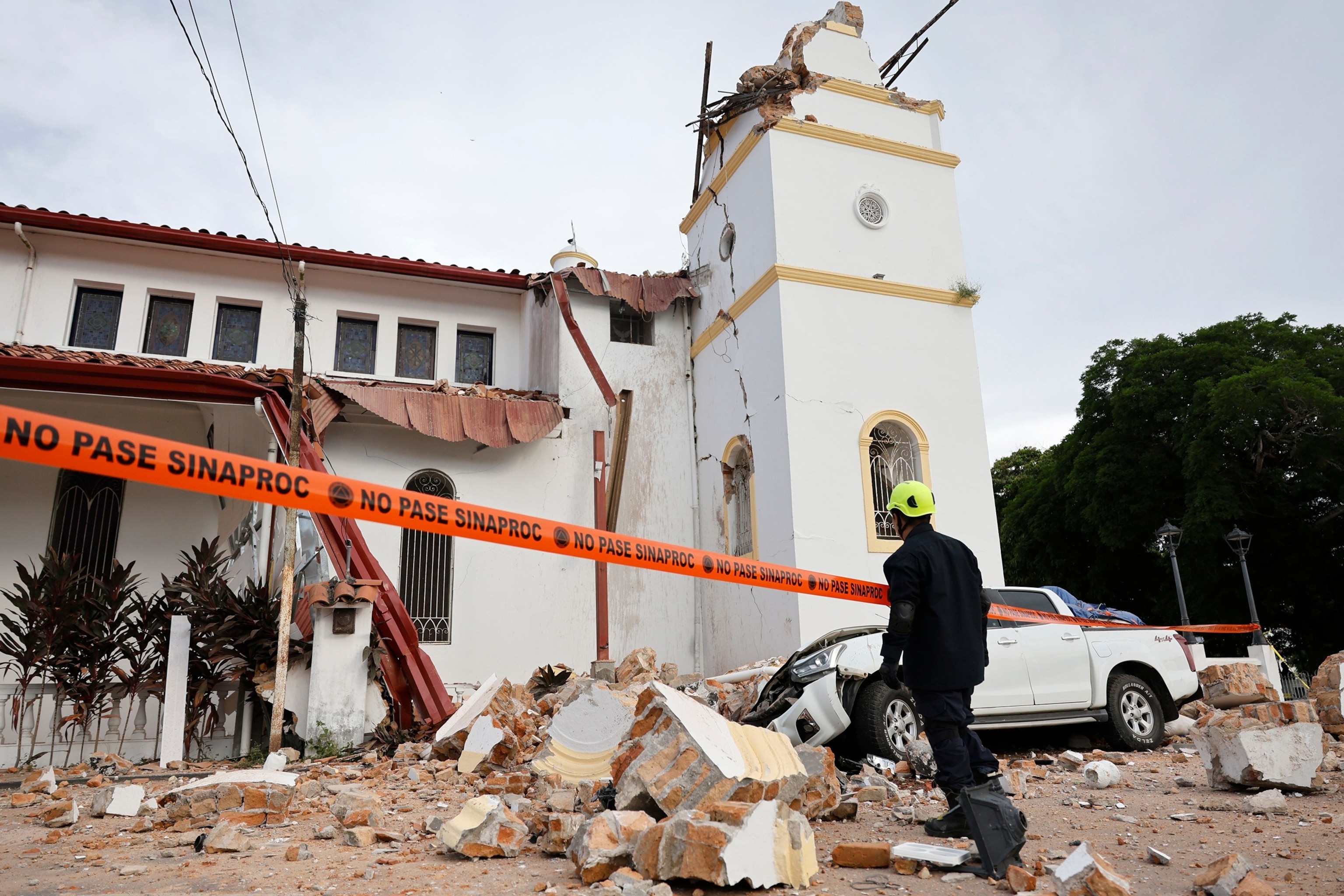
Penonomé, located in Coclé Province, sustained some of the most visible damage from the disaster. Portions of the San Juan Bautista Cathedral collapsed, including a tower structure. Nearby government buildings, hotels, and residential properties also suffered exterior damage, deep cracks, and falling masonry. Emergency officials reported at least two injuries involving individuals trapped in compromised structures in Coclé and Veraguas provinces, though authorities confirmed no immediate fatalities.
President José Raúl Mulino traveled to Penonomé to coordinate emergency relief operations. Health and civil protection ministries noted that several rural areas, including Tonosí in Los Santos Province, experienced severe access challenges due to blocked or collapsed roadways. Tocumen International Airport in Panama City temporarily suspended operations as a precautionary measure before gradually resuming regular schedules.
Critical national infrastructure largely withstood the initial impact. The Panama Canal Authority confirmed that shipping traffic through the interoceanic waterway continued normal operations without reported disruptions. Power outages affected multiple provinces as utility crews deployed to inspect transmission lines and municipal infrastructure.
Tsunami Warnings and Regional Effects
In response to the offshore epicenter, the U.S. Tsunami Warning System and regional agencies issued alerts for potential hazardous waves affecting Panama, Colombia, Costa Rica, Ecuador, El Salvador, Guatemala, Mexico, Nicaragua, and Peru. Seismological institutes reported wave surges reaching parts of Isla Cañas along the southern coast of Los Santos Province before the alerts were officially lifted later in the day.
Seismic Background
Major earthquakes are relatively infrequent in central Panama, where seismic activity historically concentrates closer to the western border with Costa Rica. Seismologists attribute the event to stress accumulation within the Azuero-Sona Fault System, part of the region's complex tectonic framework involving the Panama plate and surrounding oceanic plates. Emergency services remain on alert for ongoing aftershocks.
Comments (0)
No comments yet. Be the first to share your thoughts!